 |
 |
 |
 |
 |
 |
 |
 |
 |
 |
 |
 Previous Page
100615_YKBP_A11.pdf

Ameriprise Financial

Gubbels Salvage
Precision Painting
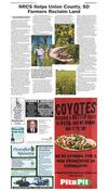
NRCS Helps Union County, SD Farmers Reclaim Land
Broadcaster Press 11
October 6, 2015 www.broadcasteronline.com
NRCS Helps Union County, SD
Farmers Reclaim Land
BY LORETTA SORENSON FOR THE NATURAL
RESOURCES CONSERVATION SERVICE
Much of the land entered into the
easement was covered with up to four feet
of sand, which was so deep it hindered
reclamation of roads and all reclamation
efforts in the area. The eroding, shifting
sands began blowing and moving
immediately after floodwaters receded.
“You can easily see the water line on
the cottonwoods that survived the flood,”
Loof says. “Dead cedar trees are also very
obvious. They didn’t survive the floodwater.
Many trees tipped under the pressure of the
floodwater’s strong current. After the water
went down, some landowners harvested logs
from the area.”
Once flood waters receded, sand
deposition made it unfeasible to farm some
NATURAL RESOURCES CONSERVATION
SERVICE, Huron, SD, October 2, 2015 –
Jefferson farmer John Corio was one
of hundreds of South Dakota farmers
who helplessly watched Missouri River
floodwaters quietly and persistently swallow
acres of farmland during the 2011 Missouri
River flood.
The record high water that spilled over
the riverbanks at the end of May 2011 and
ravaged some areas along the river into
September 2011 were estimated to cost
billions of dollars in damage.
Missouri River water levels along Corio’s
land in southern Union County have always
been affected by the upstream operation
of the Gavins Point Dam at Yankton. It’s
something Corio watched his father deal
with and learned to manage once he took
over the farm.
Corio’s flooded 26-acre tract of cropland
along with several acres of pastureland
lies at the foot of a 20-foot bluff just west
of his farm site. Both he and his father
raised crops and hay on the land since the
farm was established in 1939. While the
land always tended to be wet, the soil was
productive and careful management usually
netted an acceptable yield.
“It wasn’t unusual for changes at Gavins
Point Dam to cause water levels here to rise
around harvest time,” Corio says. “Then it
was challenging to get the crop out.”
When the 2011 flood waters came, Corio
watched soils he and his father had toiled
for years to build up and protect disappear
under 10-feet of wayward water.
“Once the water finally went down, there
was a thick layer of mud all across the field,”
Corio says. “Some people had a lot of sand
LORETTA SORENSON FOR THE
wash in during the flood. For me, it was
USDA NRCS SOUTH DAKOTA
mud.”
As Spring 2012 approached, Corio wasn’t The high water mark is easy to see
sure how or if he would reclaim the land. As on cottonwood trees growing across
the restored land recently completed
he contemplated his options, he received
in Union County. John Corio enrolled
encouraging news from his local Natural
the flood-prone cropland acres into a
Resources Conservation Service (NRCS)
Farm Bill conservation easement that
District Conservationist, Jeff Loof. NRCS
helped him to seed the area back to
was offering landowners in Corio’s area
natural prairie vegetation
an opportunity to enroll land in a special
Wetland Reserve Enhancement Program
of the land. Several irrigation systems and
(WREP) perpetual easement designed to
wells were also destroyed in the flood.
help alleviate further erosion of land along
“John was one of four farmers who
the river, restore Missouri River floodplain
worked cooperatively to develop this
wetlands and improve wildlife habitat. The
easement, protecting a total of 600 acres,”
easement agreement provided a plan and
Loof says. “They recognized that there was
funding for restoring the land.
a great benefit to them, to the area and to
“John was one of four landowners who
the nation to preserve this large expanse of
took advantage of this specially funded
Missouri River floodplain. Restored, the area
WREP opportunity,” Loof says. “Altogether,
will be important to migrating waterfowl
more than 600 acres of land adjacent to
as nesting habitat and to pollinators in this
John’s land in southern Union County that
area.”
was severely affected by the flood was
enrolled in this easement.”
The easement agreement included a
one-time per-acre payment to landowners,
which Corio invested in some more
profitable land tracts on his farm. Enrolled
acres were seeded with native plants
intended to provide wildlife habitat and
natural weed control. Plant selection also
included an emphasis on pollinator habitat.
The seed mix included many grass species
typical of the Tall Grass prairie, such as Big
Bluestem, Indiangrass, Switchgrass, Sand
Bluestem and Prairie Sandreed. Flowering
species included Purple Praireclover, Illinois
Bundleflower, Maximillian Sunflower and
Prairie Coneflower. Other species suitable for
the wetlands areas were also seeded.
“Before any reclamation could begin,
the ongoing affect of water levels as a result
of operations at Gavins Point Dam was
thoroughly explored,” Loof says. “We wanted
to be certain that reclamation was worth
doing and could be successful. Officials
also reviewed the environmental issues,
including potential effects to threatened and
endangered species, related to establishing
the easement.”
Many of the affected acres had been
previously enrolled in the Conservation
Reserve Program (CRP) because of their
marginal cropland characteristics and
vulnerability to flooding. Under the WREP
perpetual easement agreement, no
fences or water developments can be
established on the enrolled acres. If
necessary, enrolled acres are mowed
to help manage weeds. Landowners
can also realize benefit through the
use of periodic haying to facilitate
improved grass vigor and production.
This use, however, requires additional
permitting with the development of a
Compatible Use Plan.
Seeding was completed in Spring
2013. In the 2014 growing season,
seeded vegetation had plenty of weed
competition. However, by Spring 2015,
Big Bluestem, switch grass, and Indian
grass suppressed weeds. Prairie
coneflower, gray goldenrod and other
blooming perennials drew butterflies,
bees and other wildlife to the area.
“It took time for the seeded plants to
become established,” Loof says. “But now,
barring any further flooding, the land should
be self-sustaining.”
What are the chances the area will flood
again.
“About 99.9%,” Corio says. “It may not be
as bad as 2011, but it’s pretty certain it will
flood again.”
If that happens, the easement acres will
help absorb floodwaters and reduce damage
to surrounding crop acres. If restoration or
reclamation is required again, NRCS will take
on that responsibility.
“Well established vegetation will help
buffer the area from flood damage and
erosion if it floods again,” Loof says. “In the
meantime, it provides important wildlife
habitat and preservation of an area that’s
invaluable to the general public and the
residents of Union County.”
GUBBELS SALVAGE
Need a better
way to get
around?
Check out our
Automotive
Classifieds for a
reliable ride!
Broadcaster
Wanted:
• Old Cars
• RV Motorhomes
• Farm Machinery
• Irrigation Systems
• Any Type of
Scrap Iron
• Grain Bin Removal
Paying Top Dollar
Will Pick Up
Classifieds
get the
Towing Service & Roll-Off
job
Dumpsters Available
done! 1-402-640-6335
Coleridge, NE
Broadcaster
201 W. Cherry St.
624-4429
201 W. Cherry St.
624-4429
•Interior •Exterior
•Commercial
•Residential
Broadcaster
Quality Workmanship,
Reasonable Rates
Since
1983
Mike Keane, CFP®, CLU®, ChFC®
Financial Advisor
Certified Financial
Planner™ practitioner
practicioner
Keane and Associates
A financial advisory practice of
Ameriprise Financial Services, Inc.
325 West 7th Street
Sioux City, IA 51103-5417
712.258.8600
michael.f.keane@ampf.com
ameripriseadvisors.com/
michael.f.keane
PRECISION PAINTING
CLINT TUCKER
624-4621
It’s an easy
call
when you
use the
Broadcaster
classified
ads!
201 W. Cherry St.
624-4429
Ameriprise Financial Services, Inc. Member FINRA and SIPC.
to place an
ad in the
Broadcaster
!
Broadcaster
201 W. Cherry St.
624-4429
Too many
mouths to
feed?
Place an
ad in the
Broadcaster
today!
THE STRIP TILL
ADVANTAGE
Elk Point, SD
SERVICES AVAILABLE
• Custom Strip Till
• GPS Soil Sampling
• Soil Fertility Planning
• Yield Data Analysis
• Crop Consulting
Reserve your acres for this fall, Call today
JOEY HANSON
Crop Consultant/CCA
605.659.4783 • joey.hanson@diversifiedagronomy.com
• Highly efficient use of fertilizer
by directly placing below the
crops roots and minimizes
tie-up unlike broadcast
applications
• Dual placed nutrients that
promotes early, healthy root
development and creates an
optimum, fertile environment
for seed
• Increases yield while lowers
inputs such as labor, fuel, and
reduced wear and tear on
your equipment
• Offers best of both worlds:
Conservation aspects of no till,
plus, increased yields and soil
quality of conventional tillage
CUSTOM STRIP TILL • CALL 605.659.4783
Take out a
classified ad
and make a
BIG
BIG
SPLASH
BIG
SPLASH
SPLASH
in your
pocketbook!
Broadcaster
Press
WE’RE LOOKING FOR A
WE’RE LOOKING FOR A
NEW FRANCHISEE IN
NEW FRANCHISEE IN
Broadcaster
Press
VERMILLION!
BROOKINGS!
201 W. Cherry St.
624-4429
201 W. Cherry St.
624-4429
franchise.pitapitusa.com/jackrabbits
franchise.pitapitusa.com/vermillion
208-818-4713
208-818-4713